| [1] |
张双成, 李民, 刘忠, 等. 时序InSAR解译西安-咸阳地区地面沉降时空分布特征[J]. 大地测量与地球动力学, 2024, 44(4): 391-397.
|
|
ZHANG Shuangcheng, LI Min, LIU Zhong, et al. Time-series InSAR interpretation of spatial and temporal distribution characteristics of ground subsidence in Xi'an-Xianyang area[J]. Journal of Geodesy and Geodynamics, 2024, 44(4): 391-397.
|
| [2] |
蔡逸, 苏小四, 朱琳, 等. 基于InSAR技术的大庆市地面变形监测与成因分析[J]. 安全与环境工程, 2023, 30(4): 173-181.
|
|
CAI Yi, SU Xiaosi, ZHU Lin, et al. Ground deformation monitoring and cause analysis of Daqing City based on InSAR technology[J]. Safety and Environmental Engineering, 2023, 30(4): 173-181.
|
| [3] |
董建军, 梅媛, 李昕, 等. 高海拔排土场边坡安全稳定性SBAS-InSAR监测[J]. 中国安全科学学报, 2022, 32(1):92-101.
doi: 10.16265/j.cnki.issn1003-3033.2022.01.013
|
|
DONG Jianjun, MEI Yuan, LI Xin, et al. SBAS-InSAR monitoring of slope safety and stability of high altitude dumps[J]. China Safety Science Journal, 2022, 32(1): 92-101.
doi: 10.16265/j.cnki.issn1003-3033.2022.01.013
|
| [4] |
王凤云, 陶秋香, 陈洋, 等. 基于 InSAR 的煤矿采空区地表形变监测与预警[J]. 煤矿安全, 2022, 53(6):195-203.
|
|
WANG Fengyun, TAO Qiuxiang, CHEN Yang, et al. Monitoring and early-warning of surface deformation in mine goaf based on InSAR[J]. Safety in Coal Mines, 2022, 53(6): 195-203.
|
| [5] |
王霞迎, 赵超英, 尹慧芳. 地表形变时间序列 InSAR 监测法综述[J]. 地球物理学进展, 2018, 33(4): 1 430-1 437.
|
|
WANG Xiaying, ZHAO Chaoying, YIN Huifang. Review: deformation time series method with InSAR techniques[J]. Progress in Geophysics, 2018, 33(4): 1 430-1 437.
|
| [6] |
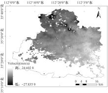
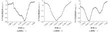
YANG Fan, ZHI Menghui, AN Yan. Revealing large-scale surface subsidence in Jincheng City's mining clusters using MT-InSAR and VMD-SSA-LSTM time series prediction model[J]. Scientific Reports, 2025, 15(1):DOI: 10.1038/s41598-025-88524-0.
|
| [7] |
李振洪, 宋小刚, 王厚之, 等. 复杂地形条件下时序InSAR大气延迟校正研究进展[J]. 地球物理学报, 2022, 65(6): 2 021-2 035.
|
|
LI Zhenhong, SONG Xiaogang, WANG Houzhi, et al. Advances in atmospheric delay correction for time-series InSAR over complex terrains[J]. Chinese Journal of Geophysics, 2022, 65(6): 2 021-2 035.
|
| [8] |
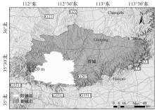
成晋松. 山西阳城县城区地质环境评价[D]. 金华: 浙江师范大学, 2013.
|
|
CHENG Jinsong. Geological environment evaluation of urban areas in Yangcheng County, Shanxi[D]. Jinhua: Zhejiang Normal University, 2013.
|
| [9] |
刘辉, 徐心月, 陈蜜, 等. 秦皇岛段明长城时序InSAR遥感动态监测[J]. 自然资源遥感, 2023, 35(2): 202-211.
|
|
LIU Hui, XU Xinyue, CHEN Mi, et al. Time-series InSAR remote sensing dynamic monitoring of the Ming Great Wall in Qinhuangdao section[J]. Remote Sensing for Natural Resources, 2023, 35(2): 202-211.
|
| [10] |
GUO Hengliang, YUAN Yonghao, WANG Jinyang, et al. Large-Scale land subsidence monitoring and prediction based on SBAS-InSAR technology with time-series sentinel-1a satellite data[J]. Remote Sensing, 2023, 15(11): 1-28.
|
| [11] |
周怡, 彭国文, 黄召, 等. 基于SBAS-InSAR和BPNN的铀尾矿坝形变智能监测与预测[J]. 中国安全科学学报, 2024, 34(4):145-152.
doi: 10.16265/j.cnki.issn1003-3033.2024.04.1693
|
|
ZHOU Yi, PENG Guowen, HUANG Zhao, et al. Intelligent monitoring and prediction of deformation of uranium tailings dam based on SBAS-InSAR and BPNN[J]. China Safety Science Journal, 2024, 34(4): 145-152.
doi: 10.16265/j.cnki.issn1003-3033.2024.04.1693
|
| [12] |
莫莹, 江利明, 孙奇石, 等. 杭州湾上虞地区SBAS-InSAR地面沉降监测分析[J]. 测绘科学, 2020, 45(10): 77-84.
|
|
MO Ying, JIANG Liming, SUN Qishi, et al. Analysis of SBAS-InSAR ground settlement monitoring in Shangyu area of Hangzhou Bay[J]. Science of Surveying and Mapping, 2020, 45(10): 77-84.
|
| [13] |
FEDERICO R, FRANCESCO C, MATTEO D S, et al. Review of satellite radar interferometry for subsidence analysis[J]. Earth-science Reviews, 2022, 235: DOI: 10.1016/j.earscirev.2022.104239.
|
| [14] |
DRAGOMIRETSKIY K, ZOSSO D. Variational mode decomposition[J]. IEEE transactions on signal processing, 2013, 62(3): 531-544.
|
| [15] |
任中杰. 基于SSA-BP-SVM模型的云龙湖水质反演研究[J]. 南京信息工程大学学报, 2024, 16(2): 279-290.
|
|
REN Zhongjie. Research on water quality inversion of Yunlong Lake based on SSA-BP-SVM model[J]. Journal of Nanjing University of Information Engineering, 2024, 16(2): 279-290.
|
| [16] |
祁云, 白晨浩, 代连朋, 等. 改进双向长短期记忆神经网络的瓦斯涌出量预测[J]. 安全与环境学报, 2024, 24(12):4 630-4 637.
|
|
QI Yun, BAI Chenhao, DAI Lianpeng, et al. Enhanced Bi-directional Long Short Term Memory neural network for gas emission forecasting[J]. Journal of Safety and Environment, 2024, 24(12):4 630-4 637.
|

 ), 支梦辉3,**(
 京公网安备 11010502045206号