| [1] |
牛莉霞, 李肖萌. 5G时代智慧矿山安全管理新模式[J]. 中国安全科学学报, 2021, 31(6):29-36.
doi: 10.16265/j.cnki.issn 1003-3033.2021.06.004
|
|
NIU Lixia, LI Xiaomeng. A new safety management model of intelligent mines in 5G era[J]. China Safety Science Journal, 2021, 31(6):29-36.
doi: 10.16265/j.cnki.issn 1003-3033.2021.06.004
|
| [2] |
李德仁, 廖明生, 王艳. 永久散射体雷达干涉测量技术[J]. 武汉大学学报:信息科学版, 2004, 29(8):664-668.
|
|
LI Deren, LIAO Mingsheng, WANG Yan. Progress of permanent scatterer interferometry[J]. Geomatics and Information Science of Wuhan University, 2004, 29(8):664-668.
|
| [3] |
BLACHOWSKI J, KOPEC A, MILCZAREK W, et al. Evolution of secondary deformations captured by satellite radar interferometry: case study of an abandoned coal basin in SW Poland[J]. Sustainability, 2019, 11(3):884-906.
|
| [4] |
董建军, 梅媛, 李昕, 等. 高海拔排土场边坡安全稳定性SBAS-InSAR监测[J]. 中国安全科学学报, 2022, 32(1):92-101.
doi: 10.16265/j.cnki.issn1003-3033.2022.01.013
|
|
DONG Jianjun, MEI Yuan, LI Xin, et al. SBAS-InSAR monitoring of slope safety and stability of high altitude dumps[J]. China Safety Science Journal, 2022, 32(1):92-101.
doi: 10.16265/j.cnki.issn1003-3033.2022.01.013
|
| [5] |
FERRETTI A, PRATI C, ROCCA F. Permanent scatterers in SAR interferometry[J]. IEEE Transactions on Geoscience and Remote Sensing, 2001, 39(1):8-20.
|
| [6] |
FERRETTI A, PRATI C, ROCCA F. Nonlinear subsidence rate estimation using permanent scatterers in differential SAR interferometry[J]. IEEE Transactions on Geoscience and Remote Sensing, 2000, 38(5):2202-2212.
|
| [7] |
段斌, 何加平, 覃事河, 等. 基于GB-InSAR技术的水电工程高边坡变形监测[J]. 中国安全科学学报, 2022, 32(增2):64-69.
|
|
DUAN Bin, HE Jiaping, QIN Shihe, et al. Surface deformation monitoring of high slope in hydropower project based on GB-InSAR technology[J]. China Safety Science Journal, 2022, 32(S2):64-69.
doi: 10.16265/j.cnki.issn1003-3033.2022.S2.0046
|
| [8] |
ZHENG Meinan, DENG Kazhong, FAN Hongdong, et al. Retrieving surface secondary subsidence in closed mines with time-series SAR interferometry combining persistent and distributed scatterers[J]. Environmental Earth Sciences, 2023, 82(9):212-228.
|
| [9] |
KHAN R, LI HUAN, AFZAL Z, et al. Monitoring subsidence in urban area by PSInSAR: a case study of abbottabad city, Northern Pakistan[J]. Remote Sensing, 2021, 13(9):1651-1669.
|
| [10] |
LI Yaxing, YANG Keming, ZHANG Jianhong, et al. Research on time series InSAR monitoring method for multiple types of surface deformation in mining area[J]. Natural Hazards, 2022, 114(3):2479-2508.
|
| [11] |
BERTIGNONO L, FERRERO V, VALVO M, et al. Photon ranging for upstream ONU activation signaling in TWDM-PON[J]. Journal of Lightwave Technology, 2016, 34(8):2064-2071.
|
| [12] |
BESOYA M, GOVIL H, BHAUMIK P. A review on surface deformation evaluation using multitemporal SAR interferometry techniques[J]. Spatial Information Research, 2020, 29(3):267-280.
|
| [13] |
JUNG H C, KIM S W, JUNG H S, et al. Satellite observation of coal mining subsidence by persistent scatterer analysis[J]. Engineering Geology, 2007, 92(1/2):1-13.
|
| [14] |
董传胜, 王新田, 陈菲, 等. 鲁西南矿区PS-InSAR沉降监测及分析[J]. 测绘与空间地理信息, 2022, 45(增1):211-214.
|
|
DONG Chuansheng, WANG Xintian, CHEN Fei, et al. Subsidence Monitoring and Analysis in the Southwestern Shandong mining area based on PS-InSAR[J]. Geomatics & Spatial Information Technology, 2022, 45(S1):211-214.
|

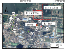
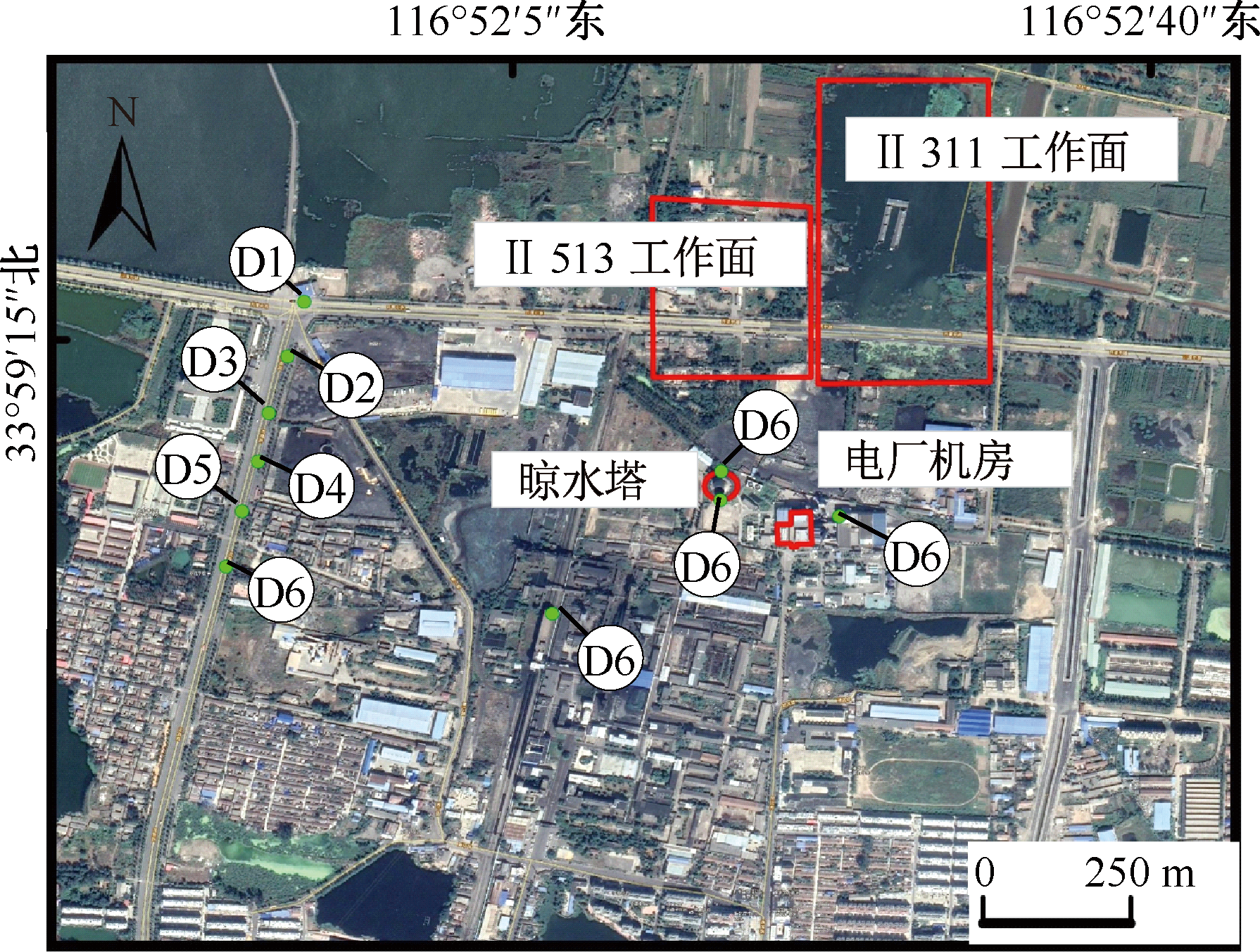
 ), 李婷婷1, 马军2, 李亚星1, 江克贵1, 赵项通1
 京公网安备 11010502045206号