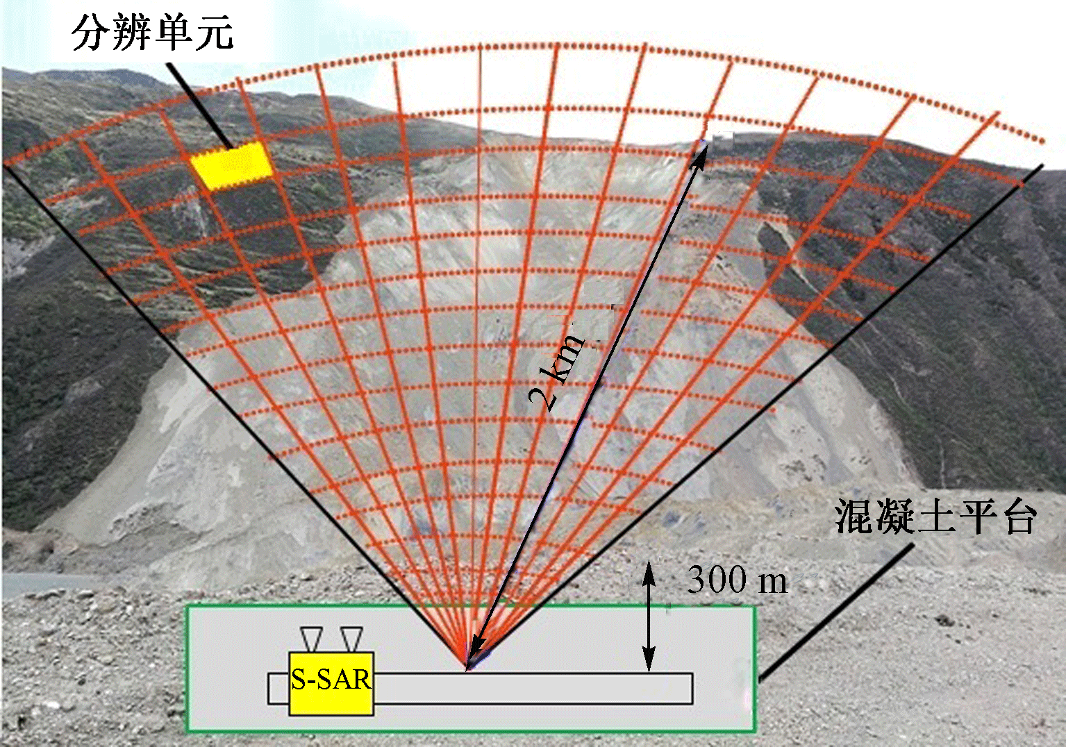
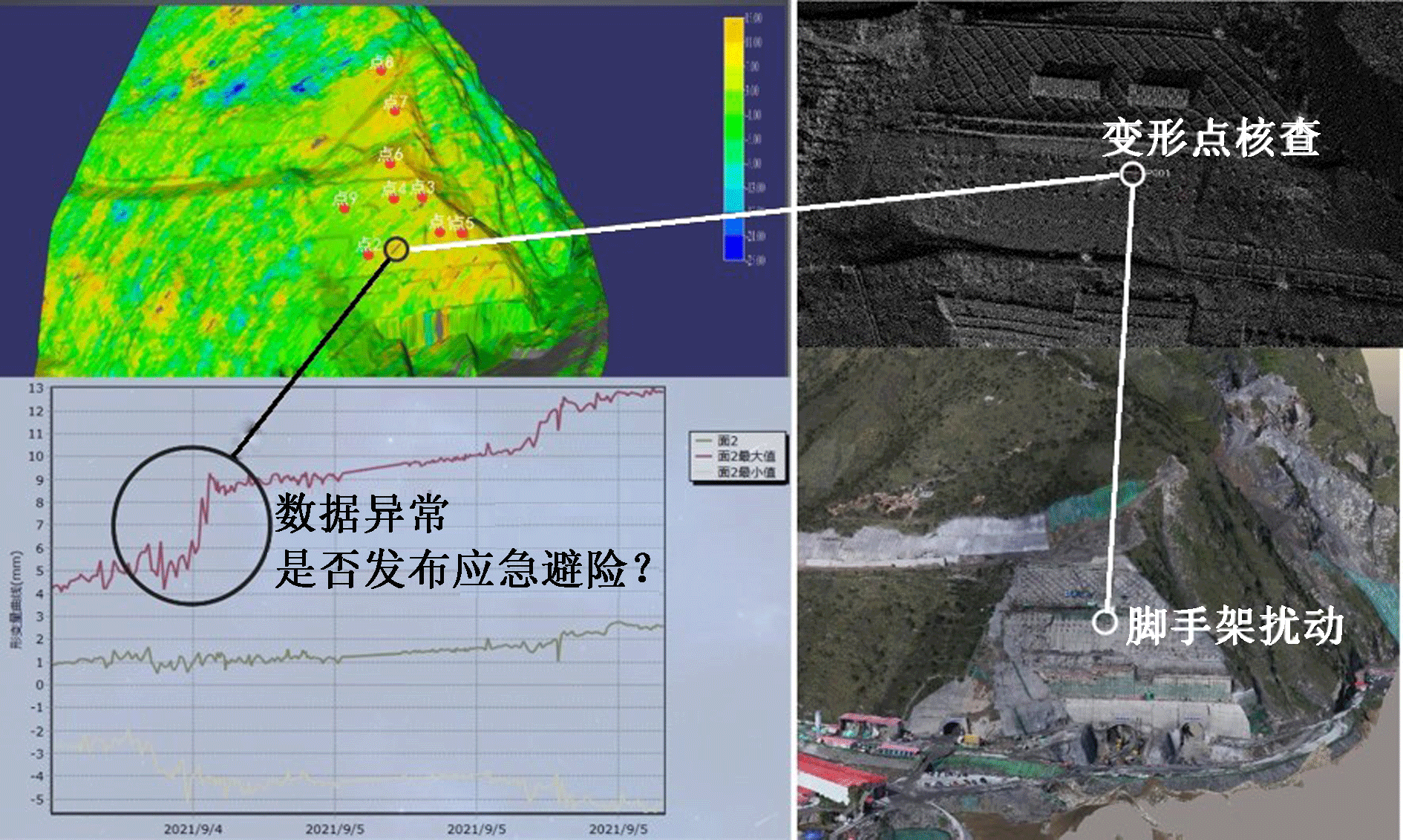
| [1] |
樊启祥, 王义锋, 裴建良, 等. 大型水电工程建设岩石力学工程实践[J]. 人民长江, 2018, 49(16):76-86.
|
|
FAN Qixiang, WANG Yifeng, PEI Jianliang, et al. Engineering practice of rock mechanics in large-scale hydropower projects[J]. Yangtze River, 2018, 49(16):76-86.
|
| [2] |
段斌, 吴晓铭, 陈刚, 等. 建在深厚覆盖层和强卸荷岩体上的混凝土面板堆石坝筑坝关键技术研究[C]. 中国大坝协会2013学术年会暨第三届堆石坝国际研讨会论文集, 2013:679-687.
|
| [3] |
DL/T 5353—2006, 水电水利工程边坡设计规范[S].
|
|
DL/T 5353-2006, Design specification for slope of hydropower and water conservancy project[S].
|
| [4] |
王军飞, 肖慎轲, 刘东烈, 等. 地基合成孔径雷达的边坡形变监测应用研究[J]. 测绘科学, 2021, 46(5):58-65.
|
|
WANG Junfei, XIAO Shenke, LIU Donglie, et al. Research on application of GB-SAR in slope deformation monitoring[J]. Science of Surveying and Mapping, 2021, 46(5):58-65.
|
| [5] |
张劲松, 吴军, 王星杰. 地基合成孔径雷达在矿区边坡监测预警应用研究[J]. 工程勘察, 2021, 49(12):59-62.
|
|
ZHANG Jinsong, WU Jun, WANG Xingjie. Application of ground based synthetic aperture radar in monitoring and early warning of mining area slope[J]. Geotechnical Investigation & Surveying, 2021, 49(12):59-62.
|
| [6] |
董建军, 梅媛, 李昕, 等. 高海拔排土场边坡安全稳定性SBAS-INSAR监测[J]. 中国安全科学学报, 2022, 32(1):92-101.
doi: 10.16265/j.cnki.issn1003-3033.2022.01.013
|
|
DONG Jianjun, MEI Yuan, LI Xin, et al. SBAS-InSAR monitoring of slope safety and stability of high altitude dumps[J]. China Safety Science Journal, 2022, 32(1):92-101.
doi: 10.16265/j.cnki.issn1003-3033.2022.01.013
|
| [7] |
郭延辉, 杨溢, 杨志全, 等. 国产GB-InSAR在特大型水库滑坡变形监测中的应用[J]. 中国地质灾害与防治学报, 2021, 32(2):66-72.
|
|
GUO Yanhui, YANG Yi, YANG Zhiquan, et al. Application of GB-InSAR in deformation monitoring of huge landslide in reservoir area[J]. The Chinese Journal of Geological Hazard and Control, 2021, 32(2):66-72.
|
| [8] |
谢博, 施富强, 廖学燕, 等. 边坡位移的EEMD-PSO-ELM模型预测方法[J]. 中国安全科学学报, 2020, 30(3):157-162.
doi: 10.16265/j.cnki.issn1003-3033.2020.03.024
|
|
XIE Bo, SHI Fuqiang, LIAO Xueyan, et al. Slope displacement prediction method based on EEMD-PSO-ELM model[J]. China Safety Science Journal, 2020, 30(3): 157-162.
doi: 10.16265/j.cnki.issn1003-3033.2020.03.024
|
| [9] |
董佳慧, 牛瑞卿, 亓梦茹, 等. InSAR技术和孕灾背景指标相结合的地灾隐患识别[J]. 地质科技通报, 2022, 41(2):187-196.
|
|
DONG Jiahui, NIU Ruiqing, QI Mengru, et al. identification of geological hazards based on the combination of InSAR technology and disaster background indicators[J]. Bulletin of Geological Science and Technology, 2022, 41(2):187-196.
|
| [10] |
周振凯, 姚鑫. 基于InSAR技术的2016年11月25日西昆仑Mw6.6地震构造变形研究[J]. 地质学报, 2018, 92(2):232-243.
|
|
ZHOU Zhenkai, YAO Xin. Tectonic deformation study of Nov.25,2016 Mw 6 6 earthquake in West Kunlun mountain based on InSAR technology[J]. Acta Geologica Sinica, 2018, 92(2):232-243.
|
| [11] |
曾琪明, 朱猛, 焦健. 地震地壳形变InSAR测量中的关键技术分析[J]. 遥感学报, 2018, 22(增1):17-31.
|
|
ZENG Qiming, ZHU Meng, JIAO Jian. Key technical issues in seismic crustal deformation measurement by InSAR[J]. Journal of Remote Sensing, 2018, 22(S1):17-31.
|
| [12] |
肖儒雅, 何秀凤. 时序InSAR水库大坝形变监测应用研究[J]. 武汉大学学报:信息科学版, 2019, 44(9):1 334-1 341.
|
|
XIAO Ruya, HE Xiufeng. Deformation monitoring of reservoirs and dams using time? series InSAR[J]. Geomatics and Information Science of Wuhan University, 2019, 44(9):1 334-1 341.
|
| [13] |
何子鑫, 于海洋, 谢赛飞, 等. 小基线集InSAR技术的小浪底大坝形变监测[J]. 测绘科学, 2022, 47(5):66-72,82.
|
|
HE Zixin, YU Haiyang, XIE Saifei, et al. Deformation monitoring of Xiaolangdi dam based on SBAS-InSAR technology[J]. Science of Surveying and Mapping, 2022, 47(5):66-72,82.
|
| [14] |
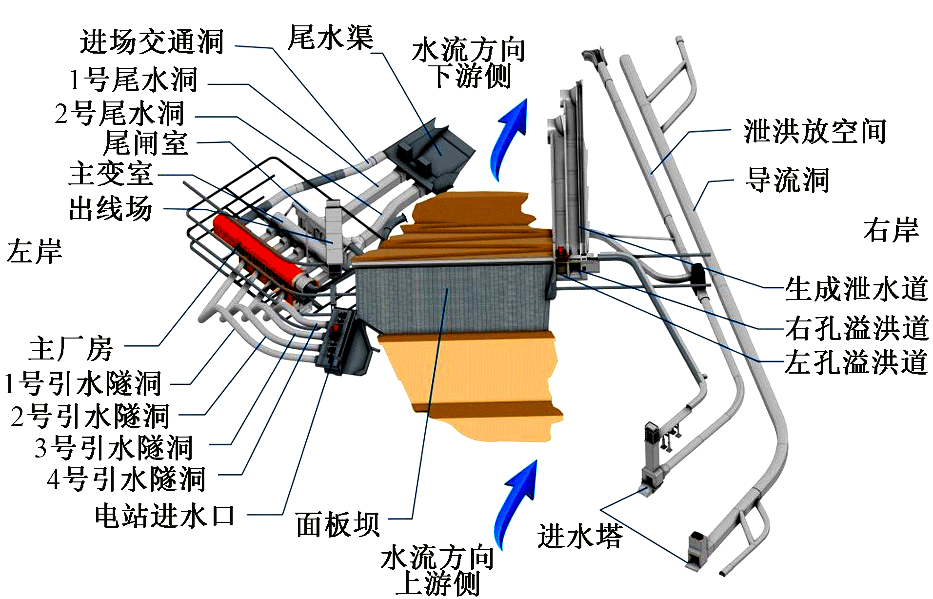
中国电建集团西北勘测设计研究院. 四川大渡河金川水电站可行性研究报告[R], 2013.
|

 ), 何加平2, 覃事河1,**(
 京公网安备 11010502045206号