| [1] |
中国化学品安全协会. 天津港“8·12”瑞海公司危险品仓库火灾爆炸事故调查报告[EB/OL].(2016-02-08). https://www.chemicalsafety.org.cn/shiguxinxi/shiguanli/detail/wd70y2mqq7nv6qp1.
|
| [2] |
8·4黎巴嫩首都爆炸事故[EB/OL].[2025-11-28]. https://baike.baidu.com/item/8·4黎巴嫩首都爆炸事故/53121701.
|
| [3] |
Liu Wei, Yan Shuaixing, He Siming, et al. Landslide damage incurred to buildings: a case study of Shenzhen landslide[J]. Engineering Geology, 2018, 247: 69-83.
doi: 10.1016/j.enggeo.2018.10.025
|
| [4] |
Luo Hongyu, Zhang Lulu, Zhang Limin. Progressive failure of buildings under landslide impact[J]. Landslides, 2019, 16(7): 1327-1340.
doi: 10.1007/s10346-019-01164-0
|
| [5] |
Ahamed T, Duan J G, Jo H. Flood-fragility analysis of instream bridges-consideration of flow hydraulics, geotechnical uncertainties, and variable scour depth[J]. Structure and Infrastructure Engineering, 2021, 17(11): 1494-1507.
doi: 10.1080/15732479.2020.1815226
|
| [6] |
刘曙光, 郑伟强, 钟桂辉, 等. 基于脆弱性曲线的寿溪河流域村镇建筑洪灾风险评估[J]. 同济大学学报(自然科学版), 2024, 52(1):68-76.
|
|
Liu Shuguang, Zheng Weiqiang, Zhong Guihui, et al. Flood risk assessment of rural buildings in shouxihe basin based on vulnerability curve[J]. Journal of Tongji University (Natural Science), 2024, 52(1):68-76.
|
| [7] |
Ferreira T M, Maio R, Costa A A, et al. Seismic vulnerability assessment of stone masonry façade walls: calibration using fragility-based results and observed damage[J]. Soil Dynamics and Earthquake Engineering, 2017, 103: 21-37.
doi: 10.1016/j.soildyn.2017.09.006
|
| [8] |
Meyers-Angulo J E, Martínez-Cuevas S, Gaspar-Escribano J M. Classifying buildings according to seismic vulnerability using Cluster-ANN techniques: application to the city of Murcia, Spain[J]. Bulletin of Earthquake Engineering, 2023, 21(7): 3581-3622.
doi: 10.1007/s10518-023-01671-5
|
| [9] |
关文玲, 李彦霏, 董呈杰, 等. 城镇燃气抢修站选址优化模型[J]. 工业安全与环保, 2025, 51(3):70-75.
|
|
Guan Wenling, Li Yanfei, Dong Chengjie, et al. Urban gas emergency repair station location optimization model[J]. Industrial Safety and Environmental Protection, 2025, 51(3):70-75.
|
| [10] |
王轶宏, 翟越, 李艳, 等. 城市燃气管网泄漏蒸气云爆炸事故风险评估[J]. 中国安全科学学报, 2023, 33(2):194-201.
doi: 10.16265/j.cnki.issn1003-3033.2023.02.0285
|
|
Wang Yihong, Zhai Yue, Li Yan, et al. Risk assessment of vapor cloud explosion accident ofurban gas pipe network under leakage condition[J]. China Safety Science Journal, 2023, 33(2):194-201.
doi: 10.16265/j.cnki.issn1003-3033.2023.02.0285
|
| [11] |
Polsky C, Neff R, Yarnal B. Building comparable global change vulnerability assessments: the vulnerability scoping diagram[J]. Global Environmental Change, 2007, 17(3/4): 472-485.
doi: 10.1016/j.gloenvcha.2007.01.005
|
| [12] |
Panahi M, Rezaie F, Meshkani S A. Seismic vulnerability assessment of school buildings in Tehran city based on AHP and GIS[J]. Natural Hazards and Earth System Sciences, 2014, 14(4): 969-979.
|
| [13] |
Rahman N, Ansary M A, Islam I. GIS based mapping of vulnerability to earthquake and fire hazard in Dhaka city, Bangladesh[J]. International Journal of Disaster Risk Reduction, 2015, 13: 291-300.
doi: 10.1016/j.ijdrr.2015.07.003
|
| [14] |
周海怡, 鲍全贵, 叶茂, 等. 基于组合赋权法的城市桥梁可靠性模糊综合评价[J]. 中国安全科学学报, 2023, 33(增刊1):156-161.
doi: 10.16265/j.cnki.issn1003-3033.2023.S1.2494
|
|
Zhou Haiyi, Bao Quangui, Ye Mao, et al. Fuzzy comprehensive evaluation of urban bridge reliability based on combination[J]. China Safety Science Journal, 2023, 33(S1):156-161.
doi: 10.16265/j.cnki.issn1003-3033.2023.S1.2494
|
| [15] |
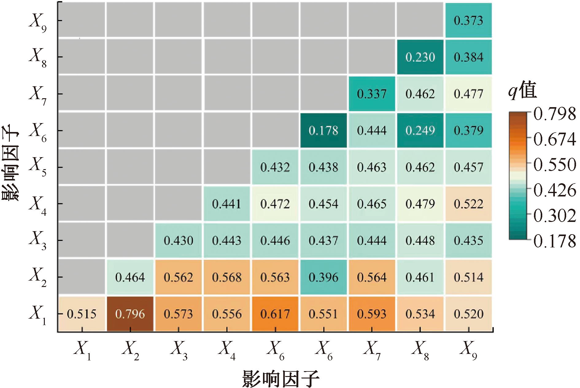
王劲峰, 徐成东. 地理探测器:原理与展望[J]. 地理学报, 2017, 72(1):116-134.
doi: 10.11821/dlxb201701010
|
|
Wang Jinfeng, Xu Chengdong. Geodetector: principle and prospective[J]. Acta Geographica Sinica, 2017, 72(1): 116-134.
doi: 10.11821/dlxb201701010
|
| [16] |
Guan Wengling, Liu Qingwen, Dong Chengjie. Risk assessment method for industrial accident consequences and human vulnerability in urban areas[J]. Journal of Loss Prevention in the Process Industries, 2022, 76: DOI: 10.1016/j.jlp.2022.104745.
|

 ), 王雨桐1, 王丽1,**(
 京公网安备 11010502045206号