| [1] |
Lu Yiding, Zhang Zhan, Fang Xinyi, et al. Resilience of urban road network to malignant traffic accidents[J]. Journal of Advanced Transportation, 2022, 2022:DOI: 10.1155/2022/3682472.
|
| [2] |
Dong Shangjia, Gao Xinyu, Ali M, et al. Characterizing resilience of flood disrupted dynamic transportation network through the lens of link reliability and stability[J]. Reliability Engineering and System Safety, 2023, 232:DOI: 10.1016/j.ress.2022.109071.
|
| [3] |
陈津怡, 李铁柱, 郭竞文, 等. 相继故障下城市轨道交通系统韧性评估方法[J]. 中国安全科学学报, 2024, 34(9): 202-208.
doi: 10.16265/j.cnki.issn1003-3033.2024.09.1963
|
|
Chen Jinyi, Li Tiezhu, Guo Jingwen, et al. Resilience assessment method of urban rail transit system under cascading failure[J]. China Safety Science Journal, 2024, 34(9): 202-208.
doi: 10.16265/j.cnki.issn1003-3033.2024.09.1963
|
| [4] |
吕彪, 高自强, 管心怡, 等. 基于日变交通配流的城市道路网络韧性评估[J]. 西南交通大学学报, 2020, 55(6):1181-1190.
|
|
Lyu Biao, Gao Ziqiang, Guan Xinyi, et al. Resilience assessment of urban road network based on day-to-day traffic assignment[J]. Journal of Southwest Jiaotong University, 2020, 55(6):1181-1190.
|
| [5] |
Ni Xiaoyong, Osaragi T, Huang Hong, et al. Resilience-oriented performance assessment method for road-traffic system: a case study in Beijing, China[J]. KSCE Journal of Civil Engineering, 2021, 25(10):1-18.
doi: 10.1007/s12205-020-0535-y
|
| [6] |
Miller-Hooks E, Zhang Xiaodong, Faturechi R. Measuring and maximizing resilience of freight transportation networks[J]. Computers and Operations Research, 2012, 39(7):1633-1643.
doi: 10.1016/j.cor.2011.09.017
|
| [7] |
Li Yang, Wu Jialu, Xiao Yunjiang, et al. Resilience analysis of highway network under rainfall using a data-driven percolation theory-based method[J]. Physica A: Statistical Mechanics and its Applications, 2024:DOI: 10.1016/J.PHYSA.2024.129639.
|
| [8] |
Wang Hongwei, Peng Zhongren, Wang Dongsheng, et al. Evaluation and prediction of transportation resilience under extreme weather events: a diffusion graph convolutional approach[J]. Transportation Research Part C, 2020, 115:DOI: 10.1016/j.trc.2020.102619.
|
| [9] |
胡小兵, 李佳茹, 刘骋越, 等. 一种评估网络结点和链接重要性的改进介数[J]. 中国安全科学学报, 2022, 32(3): 33-40.
doi: 10.16265/j.cnki.issn1003-3033.2022.03.005
|
|
Hu Xiaobing, Li Jiaru, Liu Chengyue, et al. An improved betweenness for importance assessment of network nodes and links[J]. China Safety Science Journal, 2022, 32(3): 33-40.
doi: 10.16265/j.cnki.issn1003-3033.2022.03.005
|
| [10] |
Zhang Mingliang, Xu Menghua, Wang Zhaoli, et al. Assessment of the vulnerability of road networks to urban waterlogging based on a coupled hydrodynamic model[J]. Journal of Hydrology, 2021,603:DOI: 10.1016/J.JHYDROL.2021.127105.
|
| [11] |
Li Zhuohong, He Wei, Cheng Mofan, et al. SinoLC-1: the first 1 m resolution national-scale land-cover map of China created with a deep learning framework and open-access data[DB/OL]. [2024-12-26]. https://doi.org/10.5194/essd-15-4749-2023.
|
| [12] |
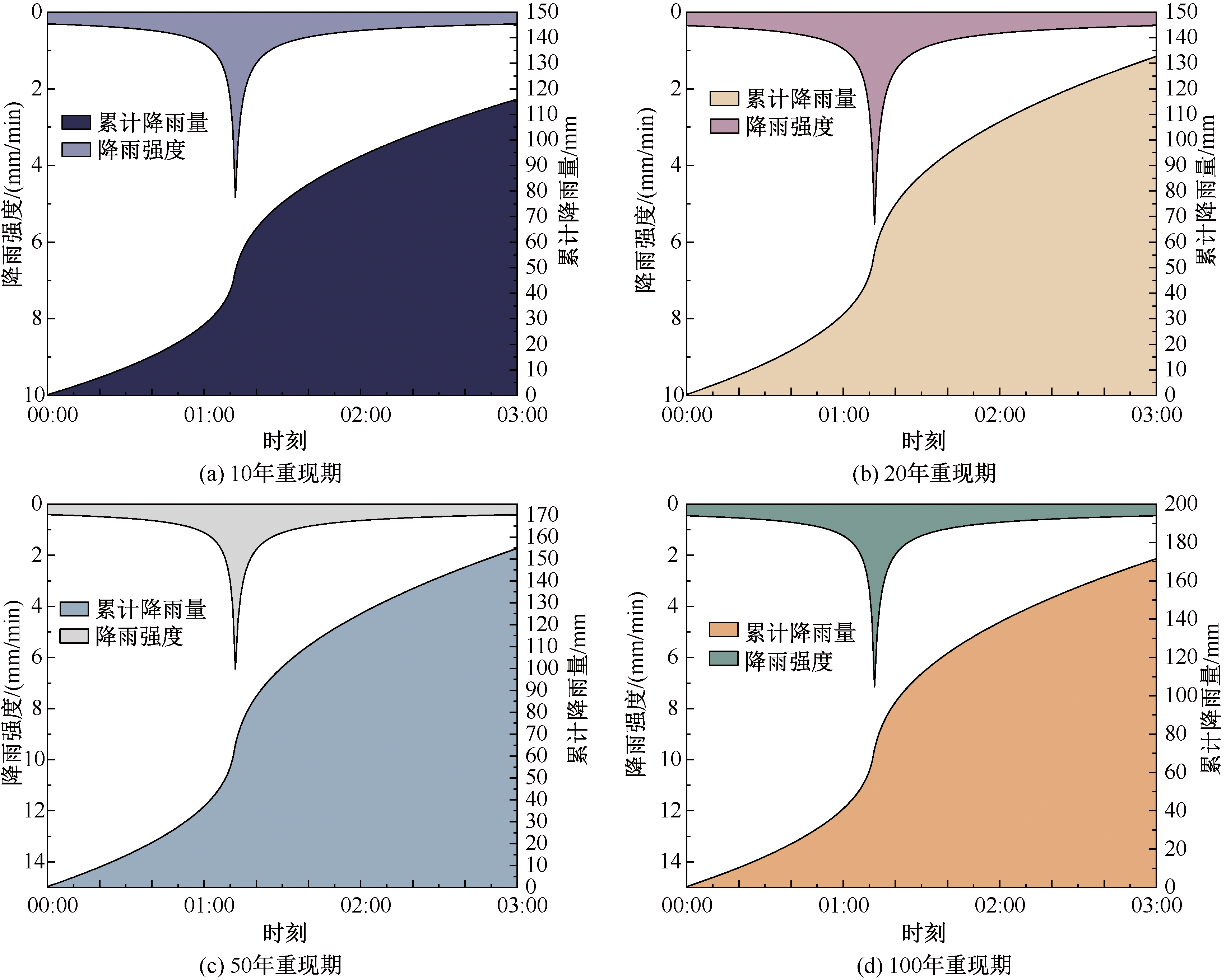
住房和城乡建设部, 中国气象局. 城市暴雨强度公式编制和设计暴雨雨型确定技术导则[Z/OL].[2025-02-16]. http://msks.qxcbs.com/file_server/upload/file/20191211/135029-5628_L.pdf.
|