中国安全科学学报 ›› 2023, Vol. 33 ›› Issue (S1): 138-144.doi: 10.16265/j.cnki.issn1003-3033.2023.S1.0132

• 安全工程技术 • 上一篇    下一篇

道路交通事故现场实景三维建模技术研究

郑金子1(), 杨奇2, 刘君1, 李亮3, 柴亚南1, 徐鹏飞1   

  1. 1 公安部道路交通安全研究中心, 北京 100062
    2 山西省公安厅交通警察总队高速五支队四大队, 山西 忻州 034000
    3 武汉大势智慧科技有限公司, 湖北 武汉 430000
  • 收稿日期:2023-03-02 修回日期:2023-05-10 出版日期:2023-06-30
  • 作者简介:

    郑金子 (1986—),女,辽宁锦州人,博士,副研究员,主要从事道路交通安全、交通运输规划等方面的研究。E-mail:

    刘君 研究员

    柴亚南 高级工程师

    徐鹏飞 工程师

  • 基金资助:
    公安部科技计划项目(2022JSYJC20); 公安部道路交通安全研究中心中央级公益性科研院所基本科研业务费专项资金资助项目(111041000000180001220501)

Research on 3D real scene reconstruction for road traffic accidents

ZHENG Jinzi1(), YANG Qi2, LIU Jun1, LI Liang3, CHAI Yanan1, XU Pengfei1   

  1. 1 Research Institute for Road Safety of MPS, Beijing 100062, China
    2 Detachment Five of Traffic Police of Shanxi Public Security Expressway, Xinzhou Shanxi 034000, China
    3 Wuhan Daspatial Technology Co., Ltd., Wuhan Hubei 430000, China
  • Received:2023-03-02 Revised:2023-05-10 Published:2023-06-30

摘要:

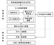
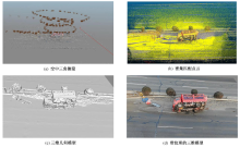
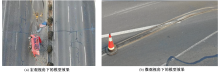
为解决传统道路交通事故现场勘查方法耗时长、复勘难、精度低等问题,探索研究道路交通事故现场实景三维重建技术。通过结合实景三维建模技术在相关领域运用经验,制定包含外业图像采集和内业模型构建的总体工作流程;针对道路交通事故现场地质形态多样、规模不定、痕迹存留短暂等特性,提出面向不同类型事故现场的无人机倾斜摄影技术方法;设计面向交通事故现场建模需要的实景三维重建算法和基于实景三维模型进行事故现场勘查测量的精度检验方法,并选取山西高速某单车侧翻事故为案例,开展事故现场实景三维模型构建和模型精度验证。研究表明:基于实景三维模型的道路交通事故现场勘查方式可减少占路勘查时间一半以上,且便于交通恢复后复勘复查;构建的事故现场实景三维模型精度达厘米级,且测量误差满足公安部发布的行业标准《道路交通事故痕迹物证勘验》要求。

关键词: 道路交通, 事故现场勘查, 实景三维模型, 倾斜摄影, 无人机

Abstract:

In response to the shortcomings of traditional methods for scene investigation of road traffic accidents, such as long time consumption, difficulty in re-exploration, and low accuracy, the technology of three-dimensional (3D) real scene reconstruction for road traffic accidents was explored. Combined with the application experience of 3D real scene reconstruction in relevant fields, the following research work including field image acquisition and internal model construction was carried out. In response to the diverse geological forms, uncertain scale, and short duration of traces at road traffic accident scenes, a series of UAV tilt photography was proposed for different types of accident scenes. The algorithm of 3D real scene reconstruction for traffic accident scene modeling was designed, and the precision inspection method of accident scene survey based on 3D real scene model was developed. A single vehicle rollover accident on Shanxi highway was selected as a case study to construct a 3D real scene model of this accident and to verify its accuracy. Research has shown that the survey method for road traffic accidents based on a 3D real scene model can reduce the survey time by more than half and facilitate re-survey after traffic recovery. Besides, the constructed 3D model of the accident scene has an accuracy of centimeter level, and the measurement error meets the industry standard of Investigation of Road Traffic Accident Traces and Evidence issued by the Ministry of Public Security.

Key words: road traffic, accident scene investigation, 3D real scene reconstruction, tilt photography, unmanned aerial vehicle